COMMON QUESTIONS #
Where can I find current trail conditions or report a trail hazard that needs to be fixed? #
Though current trail conditions aren't noted on the Association's webpage, trail users often note their experience on the
Maah Daah Trial Association Facebook Page. Please visit the Facebook page for user observed trail conditions. Also check the
US Forest Service Alerts and Closures page for trail conditions. You can report a trail problem or hazard that should be fixed on the MDHTA.COM
Trail Upkeep Form. MDHTA along with the US Forest Service will receive a copy of the report. Please provide the area location by mile marker or better yet GPS coordinates, include a photo image of the problem if you have one, and a brief description of the situation. This is very helpful in maintaining the trail.
Where does the trail begin and end? #
US Forest Service Burning Coal Vein Campground, located about 49 miles south of Medora on East River Road in Slope County, begins with Mile Post 0. From there, the 144 mile trail winds its way to its northern terminus at the US Forest Service CCC Campground in McKenzie County, located 20 miles south of Watford City, off Highway 85.
Where did the trail get its name? #
The trail name, "Maah Daah Hey", comes from the Mandan Hidatsa Indians. Tribal member Gerard Baker of the Mandan Hidatsa developed this name for the trail. In the Mandan Hidatsa language, one word or phrase can describe a picture, feeling, or situation. In this case, the phrase means "Grandfather" or "an area that has been or will be around for a long time."
Here is Gerard's account as to how he named the trail. The trail system uses a turtle as the trail marker. The turtle was a symbol of the Lakota Sioux tribe, and was honored because of its firm determination, steadfastness, patience, long life, and fortitude. "The Deuce" was named by Medora District Ranger Scot Fitzwilliams and was designed as an southern extension of the Maah Daah Hey Trail to Amidon, after a meeting with the Slope County commissioners, who asked for a trail into the Slope County seat at Amidon. The Deuce was officially folded into the Maah Daah Hey Trail in 2016 and became the 144-mile-long trail we know today.
What are the conditions like on the trail? #
The trail is open for use all year to non-motorized uses, but at various times of the year, the trail may be impassable due to snow, ice, high water, and mud. Users of the Maah Daah Hey Trail system share the same space with horseback riders, hikers, and bicyclists. Users are expected to respect the rights of others. Shared-use trails are successful when users cooperate and abide by the rules.
How I can I determine if the rivers are passable? #
To find the real time flow data on the Little Missouri River, log on to
http://waterdata.usgs.gov/nd/nwis/rt, hold your mouse pointer over your chosen location, wait a second, and the data will appear. If you choose Marmarth, then Medora, then Watford City, you will know whether the river is rising or falling. Remember the river flows from Marmarth towards Watford City, so if the river is at 1 foot at Marmarth, 2 feet at Medora, and 3 feet at Watford, it is falling, and if reversed is going to rise. As we receive more input from users, we will let you know how that data translates into your ability to cross both at Sully and near Elkhorn. A group of us did cross on horseback, at Sully, when the river was at 4.17 feet, and I would not recommend it. I believe that any reading over 3 feet requires a very experienced horse and rider. There are developing sink holes and a very strong current carrying objects at great speed towards you that increases the hazard. I believe that bikers or hiker would not be able to cross at anywhere near that depth.
Is water available along the trail? #
Each campground on the trail has hand pumped potable water throughout the season. Pump handles are removed about November 10 through April. The campgrounds are 18 or more miles apart so plan accordingly. The Maah Daah Hey Trail Map shows locations of springs, dams, dugouts, and stock tanks. This water is not certified as potable and may be difficult to filter. Some of these sites are not dependable. The Maah Daah Hey Trail south of Medora does not have springs, dams, etc. along the route. Eight water cache sites have been added to the trail by the MDHTA and other volunteer groups. Remember the most foolproof plan, especially for hikers, is to cache water before your trip.
Is certified weed seed free hay required on the Dakota Prairie Grassland? #
Yes! Certified weed seed free hay is required. A good start for locating certified weed seed free hay is to visit the
North Dakota Department of Agriculture Weed Seed Free Forage Program This is a state-wide program conducted by the ND Dept of Agriculture. If you are looking for local sources of weed seed free forage, look for the following counties on the ND Dept of Agriculture website. Counties (county seat) which the trail traverses are Billings (Medora) and Slope (Amidon). Nearby Counties (county seat) are Adams (Hettinger), Bowman (Bowman), Golden Valley (Beach), Hettinger (Mott), McKenzie (Watford City), and Stark (Dickinson).
Is a trail guide available? #
In addition to the information found on this website a trail guide written by MDHTA member Hiram Rogers can be found in our
Store. The title of the guide is
Trails of the North Dakota Badlands & Prairie A Guide to the Maah Daah Hey Trail, Theodore Roosevelt National Park, & Dakota Prairie Grasslands.
Where can I purchase a map of the trail? #
You can purchase a map at the US Forest Service offices: Medora Ranger District Office located at 99 23rd Ave West, Dickinson, ND; McKenzie Ranger District Office located at 1905 S Main St, Watford City, or you can order a map from the MDHTA website
Store. The last time the trail map was updated by the US Forest Service was 2018. Trail reroutes will be posted on the
Trail Guide tab as they become available from the US Forest Service.
Do you have an electronic version of the Maah Daah Hey Trail system map? #
Yes. Click on the
Trail Guide tab and an interactive electronic version of the map will be displayed. If you want to download the GPX files of the map for your device, click on the trail you want, scroll to the bottom of the trail detail window and then right click on the "Download GPX." Follow the instructions. You will need to repeat this process for each trail you are interested in downloading.
Hello. I and a group of friends are looking forward to riding the Maah Daah Hey this June. I've been looking at the map quite a bit and have noticed a few places where the GPX track in the interactive map differs from the line on the map marking the trail. Which one is more accurate? #
The background map that was used for the interactive map is from an older map of the MDHT when the trail was first laid out 25+ years ago. Since then, there have been reroutes of the trail to reduce the trail's impact on the landscape as well as to avoid new developments, etc. The most current printed trail map available was published in December 2018. The GPX track which is available without charge under the Trail Guide tab of this website will include any modifications made by the US Forest Service of the track as they become available. The GPX files work on portable GPS devices such as Garmin.
What types of wildlife can I see on the trail? #
This area of North Dakota provides prime habitat for a variety of mammals and birds. Mule and whitetail deer, antelope, wild turkeys, beaver, prairie dogs, and coyotes are often sighted, while an occasional golden eagle, red tail hawk, or prairie falcon may be spotted soaring above. Bighorn sheep and elk have been reintroduced into the area and can be spotted by keen observers. Mountain lions are known to roam the bad lands but are shy and rarely seen. In addition, bison
and feral horses roam the range in Theodore Roosevelt National Park.
Is dangerous wildlife a concern on the trail? #
While mountain lions are receiving a lot of attention, sightings are very rare. During 2006, bikers encounter a mountain lion. The bikers raised their bikes above their heads (Look Big) and the cat followed them for a short distance before fading into the brush along Bennett Trail. On another occasion trail users on the Long-X had a lion encounter, people yelled, and the cat took off in the opposite direction. Both encounters occurred about 8:30 am.
You are much more likely to see buffalo (within the National Park), and other small potentially bothersome animals such as skunks and porcupines. If you are concerned, do research these animals before you go on the trail. In general, to avoid all wildlife, make noise. A bell, especially for hikers, will generally move most animals away. If an animal is encountered, retreat "big". Move away quickly but do not run, continue to face the animal, and yell, lift arms, look and act big.
As for snakes, noise will help, along with being aware of the times when they are most likely to be warming themselves on the trail, short grass along the trail or in areas where vegetation is sparse. Snakes will normally not go after you; they simply strike when surprised. If you step near a snake, jump away quickly, you do not need to retreat very far, then work your way around that spot. If you like to leave the trail, be aware of their potential hiding places, hunting areas, and warming areas, and be cautious, you are in their habitat.
Is it legal to carry a firearm on the trail? I am concerned about animals that may do harm to me on the trail. #
Firearms may be carried on the trail, including Theodore Roosevelt National Park (TRNP), however few animals and as far as we know, no persons have ever threatened trail users. There were reports of mountain lion encounters in the Bennett and Long-X areas in 2006 but no one has been injured from wildlife encounters in the badlands. See the FAQs, “What kind of wildlife can I see on the trail?” and “Is dangerous wildlife a concern on the trail?” for tips in avoiding adverse wildlife encounters. Hunting is allowed in season on Forest Service lands but is prohibited in TRNP. Firearms are also not allowed in Federal buildings such as the Visitor Center and the Administrative Building in the Park. Firearm carriers should be aware that during very dry periods of the year, for example the summer 2021, the discharge of firearms, air rifles and gas guns is prohibited. See current notices on the USFS website,
Dakota Prairie Grassland - Alerts & Notices (usda.gov)
Why aren't there more mosquitoes and flying bugs along the MDHT? Does the Forest Service apply insecticides? #
No, the Forest Service doesn't spray for insects. However, bats do a fantastic job of keeping flying insects in check! The badlands is prime habitat for bats native to this area.
Are there ticks along the trail? #
Yes. Trail users should take precautions to reduce the chance of picking up these hitchhikers. Dr. Jan Knodel, NDSU Extension Entomologist has put together a list of recommended practices.
Be Smart - Do Tick Checks.
Are there any support services for trail users? #
Yes, there are four registered support providers.
Dakota Cyclery located at 36 Main Street, Medora provides shuttle service guided mountain bike tours, bike repair bike rentals, sales, accessories and parts. Contact information is phone: 701-623-4808; Jan's Cell: 701-220-4108; email: sales@dakotacyclery.com; website:
www.dakotacyclery.com.
Western Spirit Cycling of Moab, UT provides fully supported, guided mountain bike rides on the Maah Daah Hey. Their contact information is Phone 435-259-8732; email: biking@westernspirit.com; website;
https://westernspirit.com/maah-daah-hey-singletrack/.
Escape Adventures of Las Vegas, NV, provides support services for bike tours. Their contact information is Phone 800-596-2953; email: info@escapeadventures.com, website:
https://escapeadventures.com/tour/maah-daah-hey-singletrack-mountain-bike-tour/. Finally,
Blazing Adventures of Aspen, CO provides guided mountain bike tours on the MDHT. Thier phone number is 970-923-4544: email: info@blazingadventures.com; website,
https://www.blazingadventures.com/trip/maah-daah-hey/. The US Forest Service is open to registering other service providers when available.
We can't run our bikes through Theodore Roosevelt National Park on the trail and there is no by-pass of the North Unit. Do you have suggestions on how to get around the National Park? #
MDHT traverses the National Park through Congressionally designated wilderness areas and by law only hiking and equestrian use is allowed. So how does a bicyclist get around the North Unit of the National Park? Some riders have attempted to go on the south side of the perimeter fence. This route goes up extreme grades, is very rough through dense brush. People who go this way usually end up cursing this idea for good reason. Some riders will by-pass the Park exiting the MDHT on to Forest Service Road 825 near the intersection of the Long-X Trail traveling south and east 5 miles to US Highway 85, then south 1 mile to Forest Service Road 824, then 5 miles west to Bennett Trailhead. Some riders will just avoid the Park by starting from Bennett Trailhead. MDHTA has worked for a number of years to acquire an easement for a by-pass trail but without success. There is a by-pass around the west side of the South Unit of the National Park. Just follow the Buffalo Gap Trail.
Can we use our E-bikes on the Maah Daah Hey Trail System? #
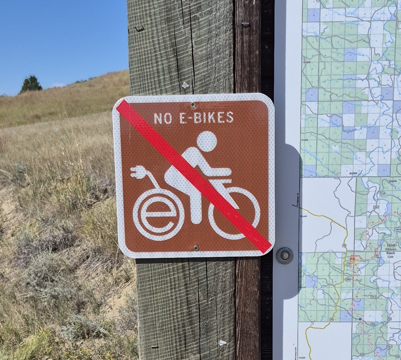
No. E-bikes use electric motors. Motors whether they are operated by electricity or gasoline are prohibited on the Maah Daah Hey Trail. E-bikes can be operated on designated roads as other vehicles. The MDHT has been designated a non-motorized trail since its inception. See the
USFS letter on E-bikes and motorized use on the MDHT. In cooperation with the US Forest Service and the North Dakota Parks and Recreation Department motorized trails have been identified in the Little Missouri National Grasslands. E-bikes and other motorized vehicles can use trails designated trails. Individuals interested in downloading a map may click
here. Additional information and a link to download a map through the Avenza App is available from the
North Dakota Parks and Recreation Department.
The self-closing gates along the trail are really interesting. Where can I get plans for these gates? #
Jerome Kuntz holds the patent to the self-closing gate used on the MDHT system. His contact information is: C-J welding, 1331 Villard Street East, Dickinson, ND 58601, Phone number is 701-227-4482.
Camping #
Is there camping along the MDHT? #
There are nine developed US Forest Service campgrounds along the MDHTA, one developed National Park Service Campground in the Theodore Roosevelt National Park South Unit, and one developed campground, Rough Rider State Park, operated by North Dakota Parks and Recreation Department near Medora. Individuals using the developed National Park campground will need to wade east across the Little Missouri from the MDHT. These campgrounds are open year-round though handles from water wells are removed about November 10 through April. Trail users can also camp in undeveloped areas on US Forest Service and National Park Service managed lands. A back country permit is required for camping in the National Park. Information about the National Park back country permit can be found
here. Back country permits are not required on US Forest Service managed lands, but users will need to follow
US FS regulations. Back country camping on State- and privately-owned land along the trail is prohibited. There are some private developed campgrounds nearby.
Where can I reserve a campsite on the Maah Daah Hey? #
Though campgrounds along the MDHT normally don't fill up except potentially during the holidays, there are two public campgrounds on the MDHT that will accept reservations. They are Rough Rider State Park Campground located about 2 miles south of Medora, operated by North Dakota Parks and Recreation and Cottonwood Campground located 6 miles north of the Theodore Roosevelt National Park South Unit entrance station.
Reservations for Rough Rider State Park Campground can be made up to 95 days prior to your stay. Reservations are not accepted for the off season from late-September to mid-May. North Dakota Park and Recreation regulations on reserving camp sites can be found
here. Reservations can be made
here. Further information about Rough Rider State Park Campground is available
here.
Reservations for Cottonwood Campground can be made at
recreation.gov. MDHT users will need to wade across the Little Missouri River to use this campground. This campground is accessible to vehicles from the main road in the park.
What are the distances between organized campsites? #
The distances between organized campgrounds along the Maah Daah Hey Trail are (approximate distance):
| Campground |
to |
Campgound |
Trail Miles |
| Burning Coal Vein |
|
Coal Creek |
29.4 |
| Coal Creek |
|
Rough Rider State Park |
19.6 |
| Rough Rider State Park |
|
Bufflao Gap |
11.8 |
| Rough Rider State Park |
|
NPS Cottonwood 1 |
8.0 |
| NPS Cottonwood 1 |
|
Wannagan |
10.0 |
| Buffalo Gap |
|
Wannagan |
16.8 |
| Wannagan |
|
Elkhorn |
21.0 |
| Elkhorn |
|
Magpie |
20.2 |
| Magpie |
|
Bennett via Cottonwood Trail |
24.4 |
| Magpie |
|
Bennett via Bennett Trail |
25.7 |
| Bennett |
|
CCC 1,2 |
19.9 |
| Bennett |
|
CCC 3 |
16.0 |
|
|
|
|
| 1 NPS regulations prohibit bikes on trails |
|
| 2 Miles based on travel along MDHT only |
|
| 3 Miles based on travel vial county roads, US 85, and MDHT |
|
Is there firewood for purchase at the campsites or do you bring your own? #
You have to bring your own, there is no firewood at the camps. It is strongly advise that firewood should be bought and used locally to prevent the spread of pests both within the state, and to prevent pests from accidentally entering the state. Many states in the Great Plains region near North Dakota have areas under quarantine for pests such as emerald ash borer (EAB), gypsy moth, and Asian longhorned beetle, and it is illegal to move any regulated items (most firewood is considered a regulated item) from quarantined zones out of those states and into North Dakota without a state or federal inspection certificate, or a stamp certifying heat treatment. A destructive insect pest can hitch a ride to non-infested areas, such as the North Dakota badlands. See additional information on firewood regulations at
Firewood | North Dakota Department of Agriculture.
TRAIL REGULATIONS #
- The trails are closed to all motorized vehicles.
- Bicycles are not allowed on the Maah Daah Hey trail as it passes through Theodore Roosevelt National Park. The Buffalo Gap Trail is an alternative route around the South Unit of Theodore Roosevelt National Park boundary for cyclists.
- Camping is prohibited on private and state land.
- Users must stay on the trail when crossing private and state land.
- Close any gates that you open.
- Stock users must use weed seed free hay or feed in order to reduce the risk of exotic/noxious plant introduction.
- Artifacts and other cultural features are protected by Federal Law. DO NOT COLLECT OR DISTURB.
- Pack out all trash and other materials. Burying trash is prohibited.
- Do NOT wash dishes or use detergents in water sources.
- For proper sanitation make toilets in a shallow hole 200 feet or more from camp, water sources, and trail.
- For your safety, DO NOT APPROACH OIL AND GAS FACILITIES; poison gases may be present.
Can I take my dog on the trail? #
Dogs (pets) may be taken on portions of the trail managed by the US Forest Service. However, they must be on a leash or restrained in developed areas such as campgrounds, and trailhead parking lots. When pets are on the trail, they must be able to respond to a verbal command and/or be leashed when approaching other trail users especially horses. Trail users should know there are certain inherent risks to pets from wildlife such as mountain lions, porcupines, rattlesnakes, and elk. In the National Park pets are prohibited on all park trails, including the MDHT in the park, and throughout the backcountry
The NDAWN weather sites provide weather data from automated weather stations located near the following towns. Historical weather data (older than 24 hours) can be obtained at the
NDAWN website.
A weather summary since midnight for today along with current weather, updated every 10 minutes, can be viewed on your computer or smartphone. Nearby weather stations are:
Beach,
Bowman,
Dickinson,
Sidney, and
Watford City
Area Webcams #
Webcam at Painted Canyon, Roosevelt National Park
The view of the Badlands at Painted Canyon updated every 15 minutes. Current weather conditions as well as air quality measurements are listed. This webcam is about 10 miles east of the Maah Daah Hey Trail.
911
McKenzie County Sheriff - (701) 842-3654
Billings County Sheriff - (701) 623-4323
State Radio (Police) - 1-800-472-2121